
The Gilgit Baltistan is the new name for the region of North most parts of Pakistan Including the major cities of Gilgit, Hunza, Skardu & Chitral. Earlier it was known as Northern Areas , It borders Afghanistan to the west-north, Tajikistan to the North, China to the northeast, the Pakistani administrated state of Azad Jammu and Kashmir (AJK) to the south, and the Indian-administered state of Jammu and Kashmir to the southeast.
The area became a single administrative unit in 1970 under the name “Northern Areas”, formed from the amalgamation of the Gilgit Agency, the Baltistan District of the Ladakh Wazarat, and the states of Hunza and Nagar. With its administrative center at the town of Gilgit, Gilgit Baltistan covers an area of 72,971 km� (28,174 mi�) and has an estimated population approaching 1,000,000. This area is part of the larger disputed territory of Kashmir between India, Pakistan and China. Northern Areas is now given a new name Gilgit-Baltistan and given their fundemental rights after 63 years, Gilgit-Baltistan now the people in this area can select their own members for National Assembely and can also take active part in the national affairs
History of Gilgit Baltistan
Before the independence of Pakistan and the partition of India in 1947, Maharaja Hari Singh extended his rule to Gilgit and Baltistan. After the partition, Jammu and Kashmir, in its entirety, remained an independent state. The Pakistani parts of Kashmir to the north and west of the cease-fire line established at the end of the Indo-Pakistani War of 1947, or the Line of Control as it later came to be called, were divided into the Northern Areas (72,971 km�) in the north and the Pakistani state of Azad Kashmir (13,297 km�) in the south. The name “Northern Areas” was first used by the United Nations, to refer to the northern areas of Kashmir. A small part of the Northern Areas, the Shaksgam tract, was provisionally ceded by Pakistan to the People’s Republic of China in 1963.
The local Northern Light Infantry is the army unit that was believed to have assisted and possibly participated in the 1999 Kargil conflict. More than 500 soldiers are believed to have been killed and buried in the Northern Areas in that action.[4] Lalak Jan, a soldier from Yasin Valley, was awarded Pakistan’s most prestigious medal, the Nishan-e-Haider, for his courageous actions during the Kargil conflict.
On 29 August, 2009, Pakistan officially granted full autonomy to the former Northern Areas. Ending their struggle for autonomy since 1947. Furthermore, the name of the Northern Areas was changed to “Gilgit Baltistan”
Geography
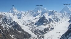
K2 as seen from Concordia
Satpara Lake, Skardu, in 2002Gilgit Baltistan borders the Wakhan corridor of Afghanistan to the northwest, China’s Uygur Autonomous Region of Xinjiang to the northeast, the Indian-controlled state of Jammu and Kashmir to the south and southeast, the Pakistani-controlled state of Azad Jammu and Kashmir to the south, and Pakistan’s North-West Frontier Province to the west.
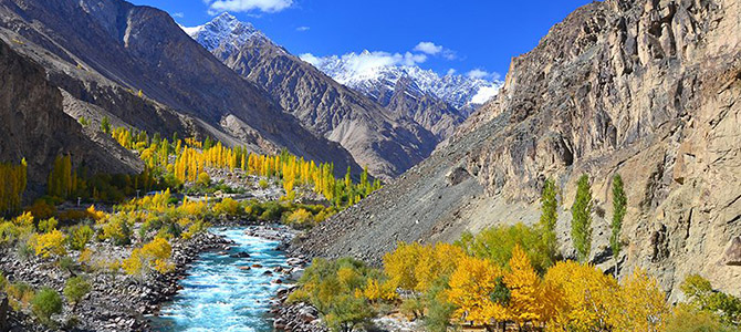
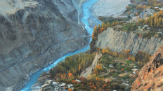
Until the war in North-West Pakistan, Gilgit Baltistan was a major destination for foreign tourists, especially serious mountaineers, because it is home to five of the “eight-thousanders” and to more than fifty peaks above 7000 meters. Gilgit and Skardu are the two main hubs for all expeditions to those mountains. The region is home to some of the world’s highest mountain ranges�the main ranges are the Karakoram and the western Himalayas. The Pamir mountains are to the north, and the Hindu Kush lies to the west. Amongst the highest mountains are K2 (Mount Godwin-Austen) and Nanga Parbat, the latter being one of the most feared mountains in the world.
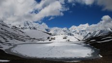
Three of the world’s longest glaciers outside the polar regions are found in Gilgit Baltistan � the Biafo Glacier, the Baltoro Glacier, and the Batura Glacier. There are, in addition, several high-altitude lakes in Gilgit Baltistan:

Add comment